【SUMMARY】
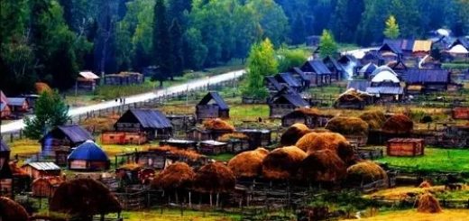
Xiate lies southwest of Zhaosu, a small traffic town and centre of Mongol & Kazakh Buddhism, on the way from Ili (Yining) to Aksu; this is the mountainous border area between China, Kazakh Stan and Kyrgyz Stan. The Xiate trail starts from the green grasslands at the foot of Halikshan mountain and it is the shortest way from Ili to the south of Xinjiang province. After the modern traffic road was built, this old way from north to south was nearly forgotten. Because of complicated geography, the modern traffic road encircles a significant part of the Tienshan mountain range from west to east and it takes nearly 2.000 km instead of only 120 km span on the Xiate shortcut route. In ancient times the trail was set up as a short cut from the branched Silk Routes of northern Asia to get to the main northern Silk Route connecting Kashgar with Xian. The Xiate trail is a most dangerous ancient pass road that heads thru the highest part of the Tienshan mountain range with the surrounding Tenggeli (father of perspiration) peak touching 6.995m elevation. On the way there are glaciers, crevasses, ice channels, glacial lakes and last but not least the tempestuous Muzhaerté river that all pose great threats to the explorers. Its also a physical challenge, as horses cant pass the trail, everyone has to carry all equipment and food in their backpack by themselves.
Best time of the year to go
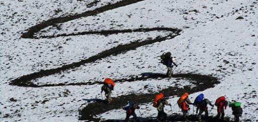
There is not really a best time to go, as in winter and spring the way is blocked by heavy snows; in summer and autumn, the Muzhaerté river stops the way because the melting glaciers give rise to strong rushing water levels that are too dangerous to wade through without loosing balance. Best shot is start trekking late spring or early summer. So we arrange to early May-early June and end of August -early September. The glaciers originate from the Bashikelimisi and surrounding 5.000m high snow mountains. They all gather near the slope into the Muzhaertè glacier which is 30 km long and 2 km wide. Because of thousand years of ice movements, the mountain rocks at both sides drop down steeply and cover many stones on the surface of the glacier. From far away the view of the glacier looks like a brown dragon winding itself from the higher white snow mountains. Because of the melting ice, three wide and deep channels are formed in the 2 km wide glacier. The torrent ice rivers rush loudly. If you loose your footing and slip into the channel, its deadly because all is ice and you have no grips and soon disappear together with the headwater underneath the big ice glacier. The trail soon became known as a “stairway to heaven” Our guider has more than 20 times successful cross experience 
【 Itinerary】
Day 1:Urumqi—Zhaosu(sleeper bus ) After welcoming you at the train station or bus station We will leave Urumqi take train or sleeper bus to Zhaosu. D2 Zhaosu-Xiate-Hot spring-C1 Arrive zhaosu County of the ILI in the morning, after breakfast we hike to Wenquan(hot spring ). From Zhaosu to Xiate way can see many monuments, Wu Sun people left the huge cemetery, like a small mountain, which stands outside the mountain pass on the vast grassland, magnificent, spectacular scenery. Starting from Wenquan(hot spring ) hiking, raise 400 meters above sea level on the day, the distance traveled 8 km to reach C1. Base Camp conditions is good, have flat grass and water. D3 C1 – Muzaerte Daban -C2 (Daban=narrow pass) Early 9:00 start on time. The day will rises 凯发娱乐0 meters above sea level,The target is at an altitude of 3400 metres of Muzaerte Daban. Daban mean narrow pass in Mongolian. Muzaerte Daban the north as the source of the Zhaosu County summer Rotte glaciers, South is the source of the Aksu Prefecture, Baicheng County Muzaerte River; On both sides has mountain of the altitude of 5000 – 5400 meters peaks. Daban near the bedrock is Silurian metamorphic rock series and Variscan granite composition, mainly in marble, marble limestone, biotite granite, granite porphyry. Today will takes 8 to 9 hours after we camp in the Muzaerte Daban , the distance of today jouney is 15 km. The camp conditions in general, has water supply, Daban minimum temperature at 10 degrees below zero. D4 C2 – Muzaerte -C3 9:00 AM start on time. Today’s plan is across the Muzaerte glacier, and down to reach the glacier camp. Muzaerte glacier is more than 30 kilometers long, 2 km wide, for the movement of ice extrusion, Glacier crack staggered uplift the hill like summer melting glaciers, in less than 2 km wide glacier rushed out of the three deep and broad, and the ice groove, Today’s journey is the highest technical in all. The ice and glacier will melt, So in the process across the glacier,leader need continues to check and figure out the most safety road. D5 C3 – Zal Wood River – Yellow wood C4 Early 9:00 departure. From this day we will walk along the right bank of the river Muzaerte , horse route forward, flat terrain, all the way down. The only difficulty of this day is to cross the river. Any team member who reached the river, HAVE TO stop and wait for everyone is arrive,wait the leader cross the river first, check the water condition clear, then members cross in group. Today we will walk about 25 kilometers, Because it is all the way down the slope and most sections of the horse road, so you won’t feel too difficult. Today stay in a Yellow wood. The condition of the camp base is ok, there has water supply. D6 C4 – Jade Mine- Pochengzi coal mine-Akesu Early start at 9:00 AM. There is a continued downward, wading, probably arrived Jade Mine at around 12 AM. Climbing a hill is the mining area . On foot for about 4 hours to the Jade Mine, which is an abandoned jade mine, Tianshan jade produced in this valley, the mine has thousands of tons of mining jade, You can pick up a few pieces then processing , it is great gift for your friends. And then go down 10 kilometers to reach the quarry. Here we will meet the driver and the car we already booked , will take 2 hours to the Pochengzi coal mine, then change to the bus to the Aksu . That night to reach Aksu City maybe the middle of the night, check in hotel. D7 Akesu – Urumqi Free activities in Akesu in the morning. At noon by bus or train we leave, return to Urumqi. You can continue to have tour go around the southern Xinjiang, after all, Have tour in Xinjiang is not easy and cheap, take the opportunity to Kashi or Hetian is a good choice that night we spent in train or bus. D8 Urumqi The morning arrived in Urumqi, the end of adventure.
【Activity costs】
RMB 4凯发娱乐0 per person Price includes: 1, Fare: Urumqi – hiking start point transfer fee, Jade mine -Pochengzi – Akesu – transfer fee 2, Room charge: Akesu 1 night room fee (single room occupancy required to make up difference) 3, Meal cost: on the way all the meals, as well as the public food costs (during hiking we guarantee member can eat to more than two kinds of vegetables every day, All the meal will cook by hiking guide assistant, But each member of the team needs to bear part of the public food and their own road meals) 4,Tickets Tickets for the scenic spots on the way 5, Hiking guide fee Every 4 members we will provide 1 professional hiking guider who also got qualifications from Chinese Mountaineering Association or Xinjiang Mountaineering Association and assistant 6, Insurance Maximum Insurance Amount of RMB 300,000 from China Pacific Insurance Company ( CPIC) 7, The registration fee Xinjiang Association Board registration fees and related fees for the border RMB 3200 per person (Do not include meals) Price includes: 1, Fare: Urumqi – hiking start point transfer fee, Jade mine -Pochengzi – Akesu – transfer fee 2, Room charge: Akesu 1 night room fee (single room occupancy required to make up difference) 3,Tickets: Tickets for the scenic spots on the way 4, Hiking guide fee Every 4 members we will provide 1 professional hiking guider who also got qualifications from Chinese Mountaineering Association or Xinjiang Mountaineering Association and assistant 5, Insurance Maximum Insurance Amount of RMB 300,000 from China Pacific Insurance Company ( CPIC) 6, The registration fee Xinjiang Association Board registration fees and related fees for the border
【Required for participants】
This activities suitable for age between 22 and 55 years old, outdoor sports enthusiasts. Applicants need to have go though some high difficulty or challenge line before, excellent health, no any acute or chronic disease, can take care of yourself, Whoever conceals his disease as a consequence of responsible for their own.
【Equipment requirements】
Tent, lighters, backpack ( above 65+10 litre), down sleeping bag (- 15 degrees, or 1000 grams of feather), moisture-proof pad, jacket (windbreaker) , climbing trousers, hiking underwear (quick drying underwear), down jacket, waterproof hiking boots, wading shoes (or rubber shoes), gloves, thick socks (7 pairs), hiking sticks, head light, sunglasses, rain cape, sun hat, warm keeping kettle , sunscreen, lipstick, tableware
Personal drugs or medicine (according to your own physical condition to prepare personal drugs):cold medicine, analgetic, Gastrointestinal drugs, antiallergic drugs,disinfectants,Dressing articles, first-aid medication.
Lishi Explore Company commitment
1, Lishi Explore Company already had the experience of 20 times successful across the line, We will never go to the wrong way, never take the team to the dangerous situation. As long as all the members obey and respect the team leader’s arrangement on the route and time, we guarantee the security and reliability of this activity. 2, If the leader personal factors (such as the wrong road, etc.) caused through failure, all costs borne by the organizers, the team members do not bear any costs. Our guider has more than 20 times successful cross experience, we are safe, because of the professional! We are good, because we respect and reverence the nature